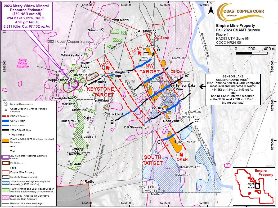
Vancouver, BC – Coast Copper Corp. (“Coast Copper” or the “Company”; TSX-V: COCO) is pleased to announce that the Controlled Source Audio-frequency Magnetotellurics (“CSAMT”) ground geophysical survey completed on its optioned, past-producing Empire Mine property (“Empire Mine” or the “Property”) located on Northern Vancouver Island, B.C. has generated three high-priority drill targets.
In December 2023, Coast Copper engaged Peter E. Walcott and Associates to complete a 5-line (totaling 5 line kilometers (“km”)) CSAMT survey over portions of the Property near the historical Benson Lake Mine representing one of numerous targets on the Property (see Figure 1). The CSAMT survey shows that known mineralization and underground workings at the past-producing Benson Lake Mine are associated with a resistivity low exhibited by two CSAMT lines over a 300-meter (“m”) x 500 m area (see Figure 2). From 1968-1972, approximately 1.2 million tonnes were mined from the Benson Lake Mine with recovered grades of 1.47% copper (“Cu”), 1.1 grams per tonne (“g/t”) gold (“Au”), 4.7 g/t silver (“Ag”) and 29% magnetite ¹ ². Based on the CSAMT features over the known mineralization, three high priority targets that exhibit similar characteristics are noted below:
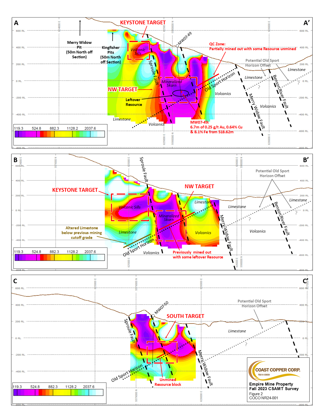
Northwest of Benson Lake Mine - High Priority Target Area (300 m x 500 m) Section A- A’
Two CSAMT lines were located to the northwest of the historical Benson Lake underground mine with the first line located just outside of the mine workings and downdip of an area historically called the “QB” Zone and the second line a further 200 m to the northwest and downdip of an area historically called the “QC” Zone. The 300 m wide resistivity low noted on both these lines also occurs in the hanging wall of the Sproule Fault as does the mined-out portions of Benson Lake mine to the southeast. Two drillholes were completed in this area in 2007 (MW07-48 & 49) by Grande Portage Resources Inc., with drillhole MW07-48 intercepting 7.5 m of a massive magnetite layer assaying 0.27 g/t Au, 0.45% Cu and 24.1% Iron (“Fe”) and MW07-049 intercepting 6.7 m of a semi-massive sulphide and dike breccia assaying 0.25 g/t Au, 0.64% Cu and 8.1% Fe ³. The combination of the Sproule Fault, resistivity low and magnetic high feature from a 2006 regional airborne geophysical survey plus the encouraging 2007 drill intercepts help identify the potential for a mineralized corridor. It is also important to note that this resistivity anomaly is open to the northwest for over 500 m until it reaches the Raven Fault.
Keystone - High Priority Target Area (100 m x 1000 m) Section B-B’
The upper or western ends of three CSAMT lines also identified an approximate 100 m thick sill-like, gently west-dipping low resistivity feature that appears to be associated with mapped Keystone volcanic sills that are associated with mineralization at the historical Merry Widow mine open pit. Limited exploration work and no drilling has occurred in this area recently identified by Coast Copper as the “Middle Trends” (see news release dated November 21, 2023) where copper and gold anomalies were returned from initial rock and soil sampling.
South of Benson Lake Mine- High Priority Target Area (200 m x 300 m) Section C-C’
One CSAMT line was completed to the south of the past-producing Benson Lake Mine, across a known fault and the Merry Widow creek. The resistivity low appears to be offset by approximately 200 m to the west, indicating that the southerly potential of mineralization may continue to the west. This resistivity low anomaly also appears to correlate with a historical “remaining mineable resource block” identified by Cominco Ltd. in December 1972 just prior to the mine being closed. One drillhole was completed in this area in 2007 (MW07-51) that encountered skarn bands between 207-328 metres down the drillhole and a 2 m massive magnetite band even though it was drilled in a southerly direction and away from the target.
It is important to note that a magnetic anomaly identified by the 2006 airborne geophysical survey continues for a further 2 km to the south. In the first kilometer, very widely spaced and sometimes abandoned and technically misdirected drilling was completed in 2006 and 2007 (drillholes MW06-25,26 & 27 and MW 07-52,53 & 54) and although assay results were not as high-grade as most of the drilling at the Merry Widow Deposit, with the value of hindsight and a better understanding of the Old Sport Mineralized Horizon, they are very technically significant with some of the results highlighted below:
- MW06-25 returned an epidote skarn with pyrrhotite from 261-275 m with a one-meter interval of 1.46 g/t Au and 0.44% Cu,
- MW06-27 returning a 20 cm semi-massive pyrrhotite interval of 0.14% Cu, 484 parts per million Cobalt and 37.5% Fe which is even more significant considering the previous 5 m interval had no recovery,
- MW07-52 returning a 1.62 m intercept of massive magnetite of 0.54 g/t Au, 0.52% Cu and 29.6% Fe, MW07-053 returning a 4.52 m intercept of massive magnetite of 34.12% Fe and
- MW07-54 returning a 14.24 m intercept of 0.12 g/t Au and 0.29 % Cu ³.
When these drillholes were completed to depth they also identified the transition to underlying Karmutsen volcanics and proved that the Old Sport Horizon continues for up to a kilometer south of the Benson Lake Mine. Now, having a better understanding of the geophysical and geological signatures, Coast Copper will use this data to help vector into areas of higher grade copper and gold associated with the magnetite bodies and the Old Sport Horizon.
Exploration Implications of CSAMT Survey and Regional Airborne Magnetics and Similarities to IOCG Deposits
Comparisons of geophysical and regional airborne magnetics with known mineralization and fault zones shows a close spatial relationship, suggesting that some of these fault zones may have been feeder zones for the magnetite mineralization which was later overprinted by copper-gold-silver-cobalt mineralization, similar in nature to iron-oxide copper gold deposits (“IOCG”) like those in Chile and those associated with subduction zones along the west coast of North America ⁵.
Based on the success of the CSAMT geophysical survey, further lines are proposed to generate new drill targets on the Property.
Association for Mineral Exploration Roundup, January 22-25, 2024
Coast Copper is currently at the AME Roundup Conference (booth #500) in Vancouver till January 25, 2024, at the Vancouver Convention Center East and will be pleased to provide further information and updates on the Company and its projects. In addition, Wyatt Bains, from the B.C Geological Survey, will be presenting a poster display on “Ore and Alteration Textures from Co-Bearing Iron Skarns: Examples from Vancouver and Texada Islands” which will also highlight some of his preliminary findings on work at our Empire Project.
Qualified Persons
The technical information contained in this news release has been prepared, reviewed, and approved by Wade Barnes, P.Geo. (BC), Coast Copper’s geological consultant and a Qualified Person (“QP”) within the context of the Canadian Securities Administrators’ National Instrument (“NI”) 43-101; Standards of Disclosure for Mineral Projects.
About Coast Copper Corp.
Coast Copper’s exploration focus is the optioned Empire Mine property, located on northern Vancouver Island, BC, which covers three historical open pit mines and two past-producing underground mines that yielded iron, copper, gold, and silver. Coast Copper’s other properties include its 100% owned Knob Hill NW property located on northern Vancouver Island, its Home Brew property in central BC, and its Scottie West property located in the “Golden Triangle” of northern BC. Coast Copper’s management team continues to review precious base metals opportunities in western North America.
On Behalf of the Board of Directors:
“Adam Travis”
Adam Travis, Chief Executive Officer and Director
For further information, please contact:
Adam Travis, CEO
Coast Copper Corp
409 Granville Street, Suite 904
Vancouver, B.C. V6C 1T2, Canada
P: 877-578-9563
E: adamt@coastcoppercorp.com
NR24-01
Cautionary Notes on Release and/or Figures
1. Historical information, maps or figures contained in this release regarding Coast Copper’s Empire Mine Property or adjacent properties cannot be relied upon as the Company’s QP, as defined under NI-43-101 has not prepared nor verified the historical information.
2. Cominco Resources, Drill Section Maps “Plan of Cominco’s Benson Lake Operations on Empire Claims Showing Ore Reserves & Proposed Exploration Program”, 1970, Private Files. While Coast Copper notes that Cominco’s historical results are not NI 43-101 compliant and have not been verified by the Company’s QP, these combined historical resources total nearly 3.154 million tonnes and will help guide Coast Copper’s exploration programs. Benson Lake Mine historical reserves recorded by Cominco Resources (1972) report a non NI 43-101 resource of 454,000 tonnes grading 0.59 g/t Au and 1.3% Cu and an Inferred resource of 2.7 million tonnes of 1.7% Cu with no Au grade calculated.
3. The 2023 Mineral Resource Estimate was prepared by Sue Bird, P.Eng., an independent Qualified Person. The effective date of the mineral resource estimate is April 26, 2023. Mineral Resources are reported using the 2014 CIM Definition Standards and were estimated in accordance with the CIM 2019 Best Practices Guidelines, as required by NI43-101. Mineral Resources that are not Mineral Reserves do not have demonstrated economic viability. There is no certainty that any Mineral Resources will be converted into Mineral Reserves. These Mineral Resource estimates include Inferred Mineral Resources that are considered too speculative geologically to have economic considerations applied to them that would enable them to be categorized as Mineral Reserves. It is reasonably expected that the majority of Inferred Mineral Resources could be upgraded to Measured or Indicated Mineral Resource with continued exploration. The Mineral Resource Estimate has been confined by a “reasonable prospects of eventual economic extraction” pit using the following assumptions, Prices are based on 3 year trailing averages, recoveries are based on preliminary metallurgical studies, and smelter terms and costs are based on comparables.
Au price of USD$1,800/oz and Cu price of US$ 3.50/lb at an exchange rate of 0.75 US$ per CAD$;
77% Cu metallurgical recovery, 29% Cu concentrate grade, 100$USD/tonne concentrate transport, 100 $USD/tonne concentrate treatment, 1% unit concentrate grade deduction, and 0.1 $USD/lb Cu refining cost
60% Au metallurgical recovery, 99% payable Au, and 8 USD$/oz Au refining cost.
Mining costs of CAD$15/tonne;
Processing + G/A costs of CAD$25/tonne;
Pit slopes of 50 degrees;
The resulting NSR equation is: NSR (CDN$) = (Cu%/100) x 3.96 x 2204.6 x 0.77 + Au x 76.05 x 0.6. The bulk density of the deposit is interpolated from sample data. The average value specific gravity used for the Mineral Resource Estimate is 3.45 at the base case cutoff.
4. Grande Portage Resources Inc. 2006 and 2007 Drilling. BC Assessment Report 28863 “Assessment Report on Diamond Drilling on the Merry Widow Property by G. Nicholson and W. Robb” and, BC Assessment Report 30002 “Diamond Drilling, Geochemical and Geophysical Assessment Report for the 2007 Program at the Merry Widow Project, W. Ravel, M. Nelson”.
5. Barra, Fernando, Reich, Martin, Selby, David, Rojas, Paula, Simon, Adam, Salazar, Eduardo, Palma, Gisella, Unraveling the origin of the Andean IOCG clan: A Re-Os isotope approach, Ore Geology Reviews (2016)
Neither the TSX Venture Exchange nor its Regulation Services Provider (as that term is defined in the policies of the TSX Venture Exchange) accepts responsibility for the adequacy or accuracy of this release.
CAUTIONARY STATEMENT REGARDING FORWARD-LOOKING INFORMATION
Certain information contained or incorporated by reference in this press release, including any information regarding the proposed Transaction, private placement, board, and management changes, as to our strategy, projects, plans or future financial or operating performance, constitutes "forward-looking statements." All statements, other than statements of historical fact, are to be considered forward-looking statements. Forward-looking statements are necessarily based on a number of estimates and assumptions that, while considered reasonable by Coast Copper, are inherently subject to significant business, economic, geological, and competitive uncertainties, and contingencies. Although Coast Copper believes the expectations expressed in such forward-looking statements are based on reasonable assumptions, such statements are not guarantees of future performance. Known and unknown factors could cause actual results to differ materially from those projected in the forward-looking statements. Such factors include but are not limited to fluctuations in market prices, exploration and exploitation successes, continued availability of capital and financing, changes in national and local government legislation, taxation, controls, regulations, expropriation, or nationalization of property and general political, economic, market or business conditions. Many of these uncertainties and contingencies can affect our actual results and could cause actual results to differ materially from those expressed or implied in any forward-looking statements made by, or on behalf of, us. Readers are cautioned that forward-looking statements are not guarantees of future performance and, therefore, readers are advised to rely on their own evaluation of such uncertainties. All of the forward-looking statements made in this press release, or incorporated by reference, are qualified by these cautionary statements. We do not assume any obligation to update any forward-looking statements.